Autumn is known for its shorter days, colorful leafy landscapes and cool, crisp nights, but Americans looking forward to these fall staples may need to wait a little longer this year as summer lingers across much of the United States.
The autumnal equinox will mark the official changing of the seasons with fall kicking off on Tuesday, Sept. 22, at 9:30 a.m. EDT. This may seem like a long ways away for some, but AccuWeather's team of long-range forecasters have been busy for weeks analyzing global weather patterns and different forecasting tools to paint a picture of what weather will unfold across the United States in the coming months. The team is led by Paul Pastelok, a senior meteorologist who has been with AccuWeather for nearly three decades.
One big factor being taken into consideration for the 2020 U.S. fall forecast is the development of La Niña. This is a phenomenon in which the ocean near the equator of the Pacific Ocean is cooler than normal, a change that can influence the global weather pattern. La Niña is the opposite of El Niño.
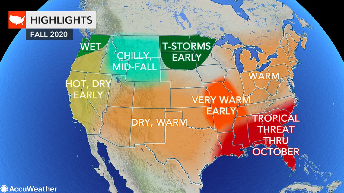
Even with the changing of the seasons in September, it may still feel like summer for many across the U.S. as warm weather holds strong over much of the country. October will be a major turning point in the season for temperatures in the central and northwestern U.S., while residents near the Atlantic and Gulf coasts remain vigilant amid a very active hurricane season.
Take a look at the complete region-by-region breakdown below:


It has been a hot summer for much of the Midwest and Northeast, and the heat is showing no signs of stopping through the first part of fall.
"The heat waves that we've seen that have been very impressive over the summer season are going to linger into September," Pastelok said. This could mean more 90-degree days for cities that have roasted in the summer heat, especially along the Interstate 95 corridor. This includes Baltimore, which set a record in July for the most 90-degree days in one month.
The prolonged summerlike warmth will not just be limited to the big cities. Areas farther inland across the Northeast and westward over the Ohio Valley and Great Lakes could experience spells of record-challenging warmth during the first half of autumn. This could include Cleveland, Detroit and Cincinnati.
Some may not like the extended warmth, but this could prove to be beneficial for some businesses amid the COVID-19 pandemic. A great many restaurants have expanded outdoor seating areas to allow for more guests to dine at the same time while maintaining social distancing guidelines and any prolonged warmth will allow these restaurants to keep revenue coming in for an extended period.
"A good portion of the fall season is gonna be beneficial to the workers that work outside and have more projects that have to get done and finished because, remember, they started out late due to [COVID-19]," Pastelok added.
As the calendar turns to October, families may start to think of trips to take in the colorful landscapes transformed by fall foliage, even if that means staying closer to home this year. However, the best of the colors may occur about two weeks behind schedule this year.
"With all the warm weather, I think it's going to be delayed again. It's kind of been the typical rule the last couple of years," Pastelok said.
Some of the best colors are expected across the southern Appalachians, which could make places such as Smoky Mountain National Park a popular destination this fall. Typically, the peak season for fall foliage in the southern Appalachians is around the final week in October.
With warm weather forecast to persist across the Northeast through the first part of fall, residents may not have to worry about snow or needing winter coats until after Halloween.
"The chance of any snow across the north is going to be very late. In fact, the freeze potential is very late this year," Pastelok said. For many, this means the first flurries may not fly until mid- to late November.
However, Pastelok warned that if there is an Arctic outbreak, the cold air flowing over the unusually warm waters of the Great Lakes could cause a "significant" lake-effect snow event. This includes places such as Marquette, Michigan; Buffalo and Watertown, New York; Erie, Pennsylvania; and South Bend, Indiana.
Warmer-than-normal conditions are in the forecast across the Southeast and mid- to- lower Mississippi Valley this fall, but the bigger story will be the heightened tropical activity.
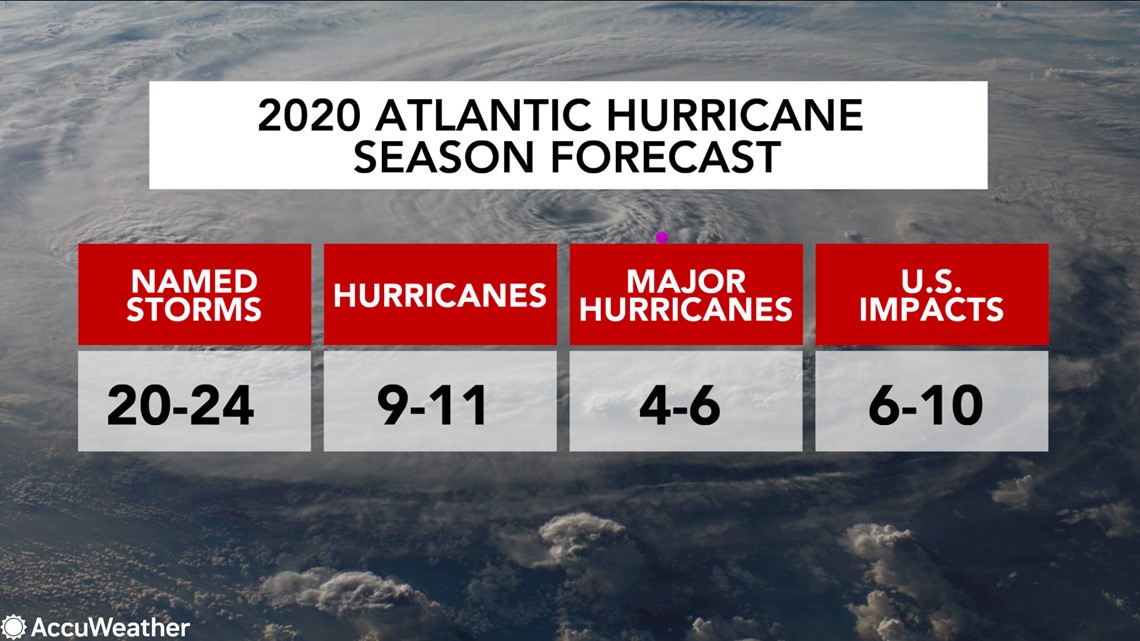
It has already been a record-setting start to the 2020 Atlantic hurricane season with nine named tropical systems forming before the end of July, a first since the satellite era began in the 1960s - and the tropics are showing no signs of slowing down heading into September, October and perhaps even November.
There are three areas that both Pastelok and AccuWeather's top hurricane expert Dan Kottlowski believe are at the highest risk for a direct impact from tropical storms and hurricanes: South Texas, the Carolinas and the coasts of Louisiana and Mississippi.
However, that's not to say that the rest of the region is in the clear. "We are nervous about the panhandle of Florida getting hit once or twice before the season's over with," Pastelok said.
The Northeast will be vulnerable to late-season hits by tropical systems, following impacts from Fay earlier this season and Isaias this week. The chances are a bit higher this year, especially in October, and threats could include damaging winds and flooding rain.
"I'm very worried that it's very possible given how warm the water is and how the pattern is setting up, that the East Coast, even all the way up to New England, should be very, very vigilant of what we see happening," Kottlowski said.


This year will continue to bring added challenges to communities in the path of a tropical system due to the COVID-19 pandemic, especially hurricane-prone states such as Florida and Texas that have become hotspots for the coronavirus in recent weeks. Any storm or hurricane could force testing sites to be shut down as winds could cause major hazards for the tents of outdoor sites.
"This year has an added layer of complexity that we just haven't experienced in recent times," Trevor Riggen said during AccuWeather's Hurricane Town Hall earlier this season. Riggen is the Senior Vice President of Disaster Services of the American Red Cross. Watch the Hurricane Town Hall here to learn more about how to prepare for hurricanes in the age of COVID-19.
Similar to areas east of the Mississippi River, people across the nation's midsection can expect the summer warmth to linger into the onset of autumn, but a dramatic change in the weather pattern is in the cards come October.
"There's one change that we do see, and a lot of it is probably produced by La Niña," Pastelok said.
La Niña could help to amplify the jet stream in October and November, leading to a potentially active weather pattern across the central Plains. This includes the risk of severe weather in places around Kansas City and St. Louis.
As the weather pattern turns more active across the Plains, it will deliver some much-needed rain to drought-stricken areas of the region.
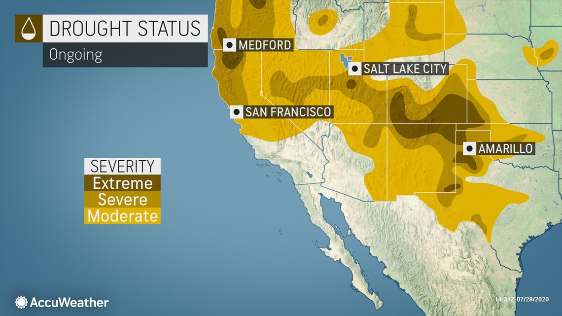
According to the U.S. drought monitor, severe to extreme drought conditions have developed in pockets of Colorado, New Mexico, Texas, Oklahoma and Kansas. The drought could potentially expand further before the mid-season shift in the overall weather pattern.


Even during the second half of fall when storms frequent the region on a more regular basis, it will not be enough to erase the drought, which could have implications for farmers.
"The concern comes in Texas getting up toward Nebraska when we look at the winter wheat planting progress, which starts September through November," Pastelok said. "If we don't start getting rain early on, it may be a little slow going for the planting season coming up this year."
The worsening drought has already taken a toll on cotton farmers in the Texas Panhandle. According to ABC7 Amarillo, 90% of the dry land cotton that was planted in Carson County did not even sprout. This is one of nine counties in the Texas Panhandle that has been designated as a primary natural disaster area, which allows farmers to be eligible for emergency loans from the U.S. Department of Agriculture.
In addition to bringing more rain and thunderstorms, the mid-season flip in the weather pattern will help to blanket the southern and central Rockies with fresh snow, allowing ski resorts to get an early base set at the start of the upcoming ski season.
"It is not uncommon for Colorado to go from very warm or hot weather to start off the season and then all of a sudden we're ending up with piles of snow and skiers are just loving it just before the Thanksgiving holiday," Pastelok said.
Residents across the West Coast will face an elevated risk of wildfires heading into the new season, but the fire danger will be short-lived for part of the region.
"This year, we are going to have an early-fall wildfire season in the Pacific Northwest," Pastelok said.
September is likely to be the most active month for wildfires across this part of the country, an area where pockets of severe drought have developed. This has left brush and potential fuel drier than normal, one of the ingredients for destructive wildfires.
The active start to the wildfire season will last for only a few weeks before a wet pattern begins to set in by October, helping to put a lid on the larger fires that ignite in September and to shorten the overall length of the fire season.
"Definitely look for a shorter wildfire season in the Northwest, but still a strong one from places like eastern Washington, Oregon down into Northern California," Pastelok added.
Meanwhile, farther south in California, it will take a longer time for the onset of the rainy season to arrive with storms being few and far between until the tail end of autumn and early winter. As a result, the fire season in Central and Southern California will last longer than it will in the Pacific Northwest.
October, in particular, is forecast to bring several Santa Ana Wind events, making it the busiest time for wildfires in Southern California.
Similar to tropical storms impacting the East Coast, the upcoming wildfire season in the West could look different due to the coronavirus pandemic. In addition to complicating plans for evacuation shelters, air pollution caused by wildfires could potentially increase the likelihood of being infected with COVID-19, The San Diego Union-Tribune reported.
Any air pollution from wildfire smoke could heighten people's chances of becoming infected with the coronavirus, Mary Prunicki, a senior research scientist at Stanford's Parker Center for Allergy and Asthma Research, told The San Diego Tribune. Prunicki also cautioned that studies have shown that heavy wildfire smoke can also exacerbate flu season, which typically begins in October.
Californians may also face rounds of power shutoffs on days with extreme fire danger, a tactic used by power companies in 2019 to lower the chances of new fires sparking. These outages could significantly disrupt those that are telecommuting for work due to COVID-19.
Wet weather is not projected to return to Central and Southern California on a more regular basis until the end of autumn and early winter, eventually marking an end to the wildfire season.
The prolonged dry pattern could be to the benefit of those that had plans to travel to national parks across the state earlier in the year but ultimately had to postpone their trips due to COVID-19.
On the flip side of the coin, the late arrival of meaningful storms will delay the onset of snow for ski resorts across California, especially those in the southern Sierra as well as the San Gabriel and San Bernardino mountains.

