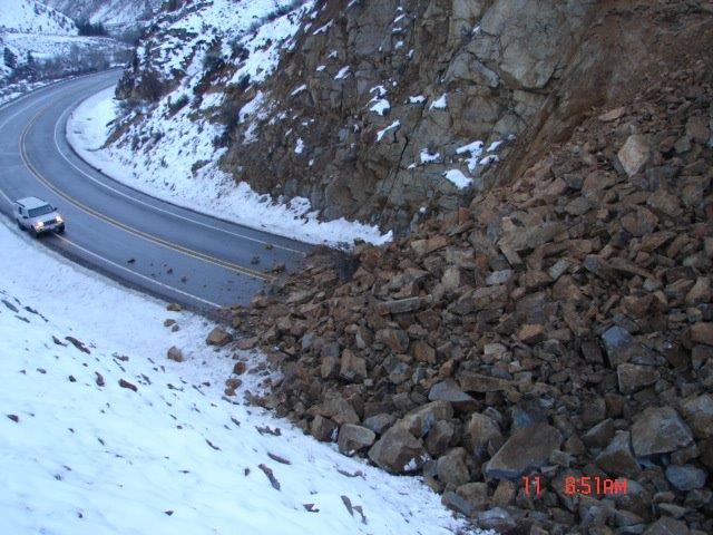
With all of its heavy rain and rolling hills, the Pacific Northwest is one of the most landslide-prone regions in the country. This is why the Washington State Department of Natural Resources (DNR) and the Oregon Department of Geology and Mineral Industries (DOGAMI) released a new guide on Thursday to help homeowners avoid hazardous areas when buying property, identify warning signs of possible landslides and know who to call when they do.
The first pages of "A Homeowner's Guide to Landslides" explain exactly what a landslide is, how even a few inches of movement in the ground can disrupt septic, sewer, and water lines; and what you can do to avoid those risks.
The different types of landslides--rational slides, earthflows, and debris flows--all occur in areas with steep slopes and are typically triggered by wave or stream erosion, earthquakes, rain or snowfall and human activities like construction. After a landslide, according to the guide, you might see the following: cracks in the soil, tilted or bent trees, newly wet ground, uneven terrain, sagging utility lines, sunken or broken roads and leaking or broken water pipes.
Tree roots can greatly reduce the likelihood of a landslide and will continue to stabilize the soil on steep slopes even five to eght years after the tree has been cut down. The guide recommends that native plants be used to cover slopes and, furthermore, that people avoid adding water, adding yard waste or excavating soil near steep areas of land.
“Our job is to understand Washington’s complex geology and how it impacts the people who live here,” State Geologist Dave Norman said in a statement. “We want to make sure we put that information into their hands.”
Heavy snow and rainfall this past winter only proved that landslides are one of the most common—and destructive—natural hazards in the area. The DNR and DOGAMI, both of which are the official geological surveys of Washington and Oregon, respectively, want to help people better understand these geological events.
Ever since the Washington State Legislature mandated that the DNR “collect, analyze, and publicly distribute detailed information about our state’s geology using the best available technology.” The technology, known as “lidar”—which stands for Light Detection And Ranging—allows the DNR to survey land using a laser to render detailed three-dimensional models of terrain, without the obstruction of trees and other vegetation. Using lidar, both the DNR and DOGAMI have been able to collect high-resolution data that can be used to produce maps of the region’s geological hazards, especially landslides.
Washington State experiences hundreds to thousands of landslides each year that can lead to the destruction of roads and the loss of lives, according to the DNR. Each year the Washington State Department of Transportation allocates $15 million for the mess landslides leave behind on state highways. Across the country, each year landslides account for $2 billion in damages and an estimated 25 to 50 deaths.
Hopefully, the new guide will help reduce those numbers.


