
DARRINGTON, Wash. — In the 10 years since the devastating landslide near the Oso community, scientists and policymakers have worked to better understand landslide, but local experts say there is still work to do in terms of understanding the risks to life and property in run-out zones, and in educating homeowners about whether their neighborhoods could be impacted.
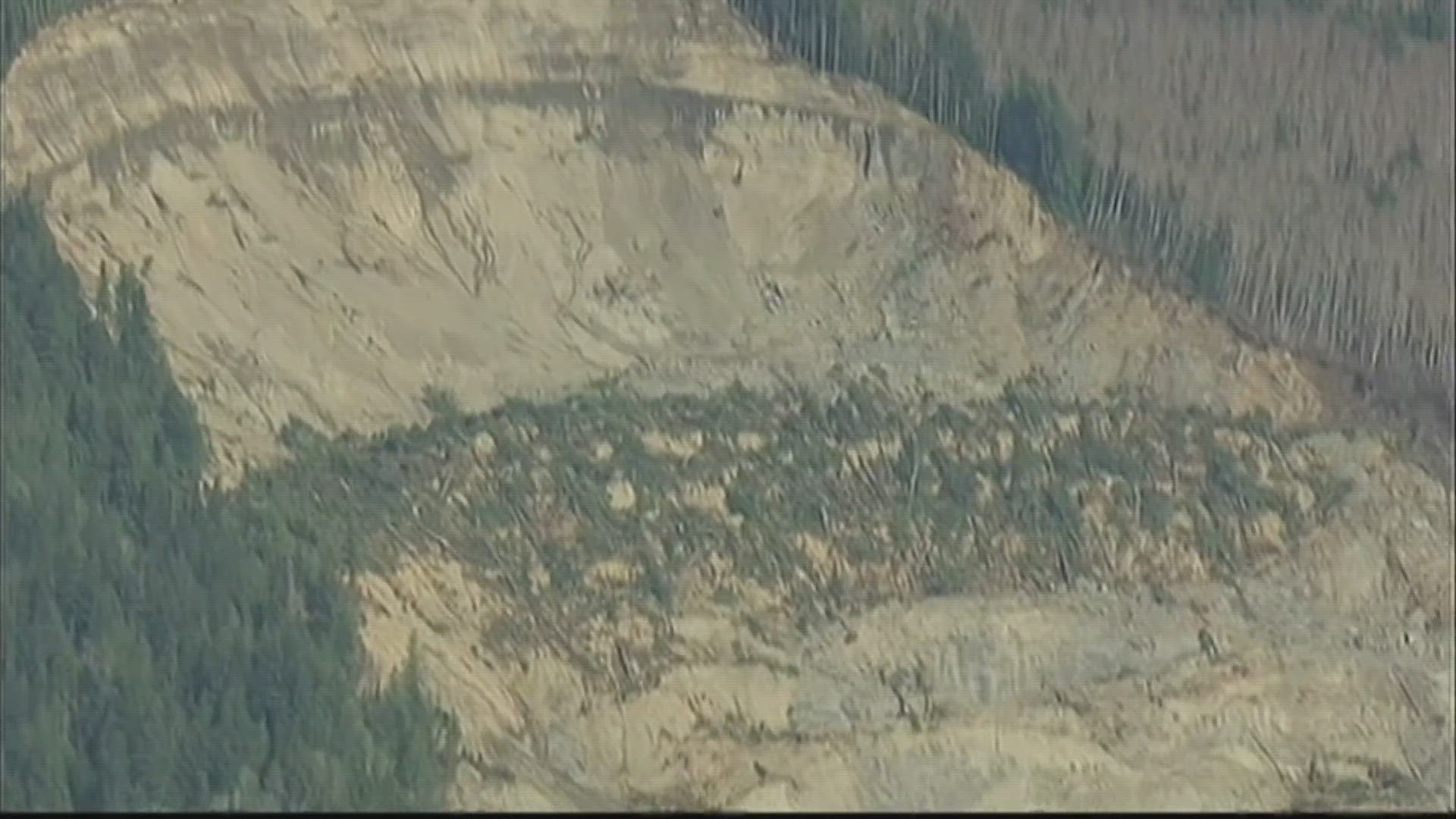
The slide happened March 22, 2014 on a hill that had already failed multiple times in the past, but this particular event was larger, traveled a greater distance and had more force behind it than others in the past. Scientists believe groundwater and rainfall at the time played a major role in the speed and impact of the slide and that it may not have moved as far if the material was denser and drier.
University of Washington Geomorphology Professor David Montgomery has studied landslides for decades and was part of the team that produced a post-incident report.
"The goal was to collect data in a framework that other people could use to try to figure out what caused the event, what happened. And we got out to the site over Memorial Day weekend that year, months after the slide," Montgomery said. "Why did we wait that long with a mission like that? It was because recovery operations were going on, and you don’t go out and do science in the middle of a recovery operation."
The Geotechnical Extreme Event Reconnaissance team began compiling data and studying the history of the site, from the rainfall that triggered the event to the kinds of land use in the area. Montgomery said there's still some argument about the geological details of what happened at the site. But what the team report documented and what still seems like the best explanation to him is that the lower part of the hillside that had failed before played a role.
According to Montgomery, there was a landslide in 2006. During the landslide in 2014, debris flowed over that of the previous slide, which was saturated by recent rainfall and gave way.
"The analogy I like to use is a boot stomping a mud puddle; you’ve got a big force coming down onto a saturated material that was very sandy, very granular, and prone to liquefaction," he said.
Glenn Farley is a retired KING 5 reporter who covered recovery operations, scientific analysis and policymaking on landslides in the weeks, months and years after the slide. He is still deeply touched by what he witnessed.
"We had been in there in 2006 where part of that wall had calved off and blocked the river and pushed the river through that Steelhead Haven neighborhood," Farley said. "Eight years later, the people we had met - some of the people we had met before - were gone."
Farley said in the initial days following the slide, it was not clear exactly what or how it happened. That information came out in pieces as geologists had a chance to study the path and understand why it caused such significant damage.
Montgomery said that the first phase triggered a "debris avalanche" that went across the valley bottom, causing immense damage. A second piece of the hill fell down, essentially rotating or collapsing into the hole left from the first piece.
The U.S. Geological Survey confirms the slide involved "rotation, translation and flow mechanisms" and can be referred to as a debris-avalanche flow.
"There’s been debris avalanches in the past, they’re not unknown to geologists, but we didn’t really have a lot of experience with them in western Washington," Montgomery said. "One of the things that really came out of sort of studying what happened there is that there have been other events like that in the geological past, in this region, because we have a setup here of steep slopes with glacially deposited sediments."
According to the USGS, research indicates "the landslide's average speed was about 40 miles per hour, with maximum speeds likely even higher." According to the agency, the area overrun by the landslide was about a half-square mile and the landslide dammed the North Fork Stillaguamish River to a depth of as much as 25 feet.
Montgomery said Oso was a "deep-seated landslide," meaning it involved more than surface-level materials. Those materials included glacial sediments, with sand and gravel near the top and silt and clay further down. It was a "deep-seated" slide because the materials made up the hillside, he said.
The debris avalanche onto a very wet, saturated layer prone to be liquefied caused the long run-out.
"It was essentially a reactivation of a slide that had failed before, but this time it went further, faster, presumably due to all the rain we had," Montgomery said. "It was an incredibly wet month before. Ironically the slide happened on the first nice, clear day of spring, but that’s kind of how you know there was groundwater involved in triggering the initial failure, because it didn’t happen during intense rain, it happened after the rain had stopped."
Light Detection and Ranging (LIDAR) helped scientists understand the landscape before and after this and other landslides. Farley said scientists conducted a series of LIDAR flights over the valley before the 2014 slide.
"One of the things they knew fairly early on was just how much material had been lost out of this hillside because they could see what it looked like after the slide and they could see what it looked like before the slide," Farley said.
Montgomery said using LIDAR data, geologists came to "sobering" conclusions about how frequently landslides happened in that segment of the valley. Records also showed past occurrences. Though people knew about the risk of slide, there wasn't clear information about just how dangerous it could be. Montgomery hopes more analysis will be done in the future in landslide-prone zones to understand that piece of the puzzle.
"There’s still a big gulf between landslide hazard assessment in terms of identifying landslide-prone slopes or existing landslides, which LIDAR data is fabulous for. But it’s much more complicated to predict where a slide may go," Montgomery said, adding that information from the Oso landslide could help in evaluating whether other areas might be vulnerable to similar situations.
Montgomery said there's also room to improve discussion and clear decision-making regarding forestry practices on existing deep-seated landslides.
Farley said it's tough to look back and remember what he witnessed in 2014, but he hopes taking stock of the science and using information in land-use planning will help to save lives in the future.
"And that’s why we really need to be smart about the geology, moving forward, in this state," Farley said.
From the KING 5 Archives: Remembering the Oso landslide one year later