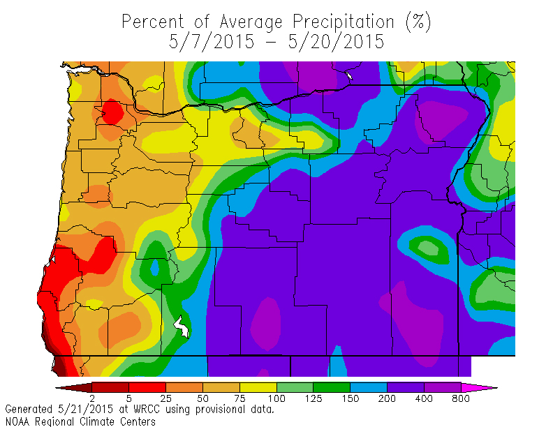
We've seen an interesting distribution for rainfall across the Northwest. Certainly a welcome change for some.
![635682534989596176-washington-rain [ID=27974953]](http://www.gannett-cdn.com/-mm-/e1b45c6f012d9acbbe3444c502d9583e949b1216/r=500x386/local/-/media/2015/05/26/NWGroup/KING/635682534989596176-washington-rain.jpg)
The map of Washington shows what percentage of average of rainfall we've seen over the past two weeks. The lighter red and orange colors west of the Cascades showing rainfall lower than average, while darker purple colors east of the Cascades shows rainfall much higher than average.
The same case goes further south over Oregon. Areas east of the Cascades have been getting rainfall much higher than average over the past 14 days.
![635682534988348136-oregon-rain [ID=27974949]](http://www.gannett-cdn.com/-mm-/e1b45c6f012d9acbbe3444c502d9583e949b1216/r=500x386/local/-/media/2015/05/26/NWGroup/KING/635682534988348136-oregon-rain.jpg)
A closer look at the numbers, and one is pretty startling. Quillayute, WA sits in the rainforest region of the Olympic Mountains. So far this month, they've seen only 0.65" of rain which is close to 3" below average. A similar story plays out for cities along Interstate 5.
However, cities out east where you wouldn't think would be getting much rainfall have been hit with showers and thunderstorms at a regular rate. Cities like Yakima, Baker City, Burns, and Pasco all have higher than normal rainfall totals so far this May. This is fantastic news, especially for those dealing with extreme drought.
![635682534974931706-washington-drought [ID=27974951]](http://www.gannett-cdn.com/-mm-/c711c85d58e411988f13438d0dec93db9715f141/r=400x400/local/-/media/2015/05/26/NWGroup/KING/635682534974931706-washington-drought.png)
Why we're seeing the rain? A broad area of low pressure over the western United States.
That is changing our typical west to east flow to more east to west. Moist, unstable air continues to filter into areas east of the Cascades allowing thunderstorms to develop. And when that east to west flow pattern persists, air piles up along the eastern slopes of the Cascades which generates more rainfall.
Meanwhile, on the coast, you end up with the opposite. Air descends down the mountains and dries up. We'll have to wait and see how long this lasts.
![635682534971499596-oregon-drought [ID=27974955]](http://www.gannett-cdn.com/-mm-/c711c85d58e411988f13438d0dec93db9715f141/r=400x400/local/-/media/2015/05/26/NWGroup/KING/635682534971499596-oregon-drought.png)
On a final note, our friends at the National Weather Service also pointed out that San Diego has had nearly 2" more rainfall than the Olympic rainforest this month. That doesn't happen very often!


