SEATTLE — An early-season heat wave is expected for Seattle and western Washington this Mother's Day Weekend and continuing into early next week.
Confidence is high that we will see record-breaking warm temperatures, soaring 15-25 degrees above average by the weekend. The average high in Seattle is 66°, but highs are expected to climb into the mid to upper-80s with some lower 90s as a strong upper area of high pressure builds over the Pacific Northwest.
Weather setup this weekend

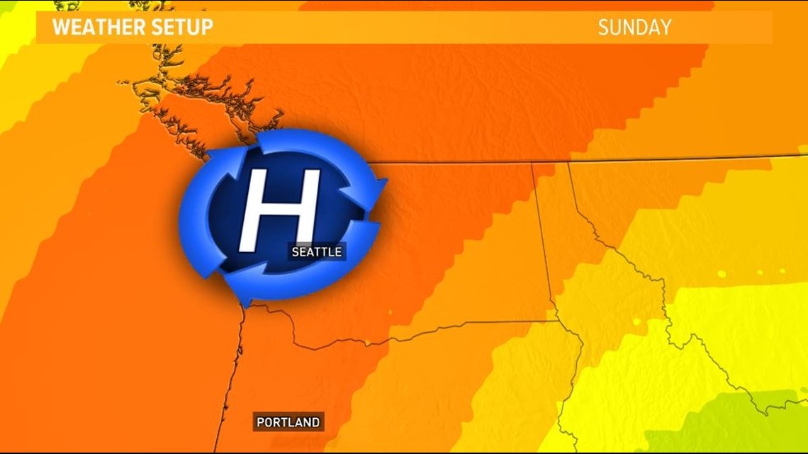
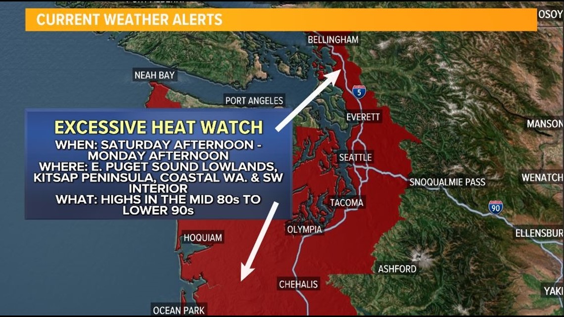
The Seattle National Weather Service issued an Excessive Heat Watch for much of the Puget Sound lowlands and the coast that will go into effect Saturday afternoon and expire late Monday afternoon.
KING 5 has activated First Alert for this weather event, which could affect lives, property or travel in the Pacific Northwest region. During this event, the First Alert Weather Team will bring you the latest information to keep you and your family safe.
Excessive Heat Watch

The start of the warming trend began on Wednesday with highs climbing into the lower 70s, Seattle hit 71 Wednesday afternoon, and we're going to see some areas warm into the mid-70s this afternoon south of Seattle.
The hottest period during the heat wave is expected for this Friday through at least next Tuesday, with highs climbing up to around 80° Friday. We will see temperatures jump into the lower to mid-80s Saturday, when the Excessive Heat Watch goes into effect, and the upper 80s and lower 90s Sunday through Monday. Highs stay well into the 80s for Tuesday as the area of high pressure continues to have a strong influence on the Pacific Northwest weather.
Favored areas to see temperatures in the lower 90s Sunday and Monday will be interior parts of the Puget Sound lowlands, the Cascade foothills and valleys, and the Southwest Interior. These areas will also see low temperatures stay in the 60s.
Because of the lack of cooling and prolonged period of heat, there's an increased risk for heat-related illnesses, which is why the Seattle National Weather Service issued the Excessive Heat Watch.
While Seattle and most of the I-5 corridor are in a moderate heat risk late this weekend and early next week, parts of the western Washington lowlands will see a major heat risk, or level 3 out of 4, according to the Seattle National Weather Service.
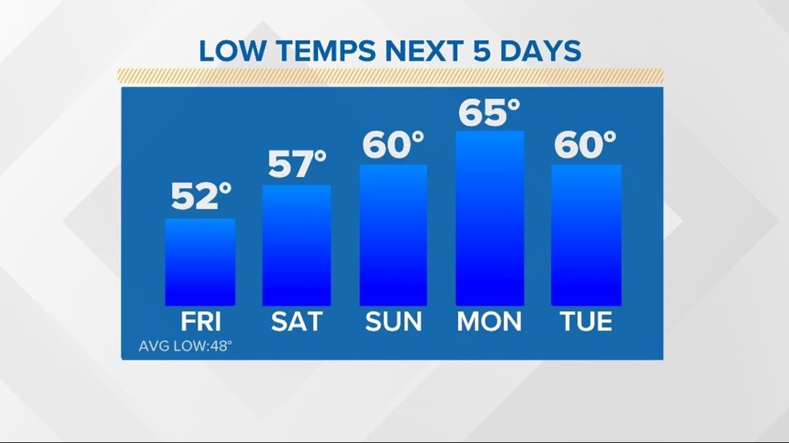
A big reason for the higher heat risk is not only due to the prolonged period of high temperatures well above average but also because the overnight lows look to stay in the 60s by the weekend and early next week. This will increase the risk of heat-related illness.
Notice how mild the overnight lows stay across the Emerald City by this upcoming weekend, possibly not falling below 65 by Monday.
5-day low temperature forecast for Seattle

The afternoon heat will not only be well above average, but it'll approach record territory for many areas across western Washington.
Near record or record daily highs are possible for Seattle from Friday through Tuesday with the best chance of setting a new daily record coming both Sunday and Monday. This is when the daily record high temperatures could be broken and possibly the earliest 90-plus day for Seattle, which is currently May 17 from back in 2008.
Seattle normally sees its first 90-degree day on July 3.
Here's a look at the forecast highs and records for the Emerald City over the next 5 days.
5-day high temperature forecast for Seattle

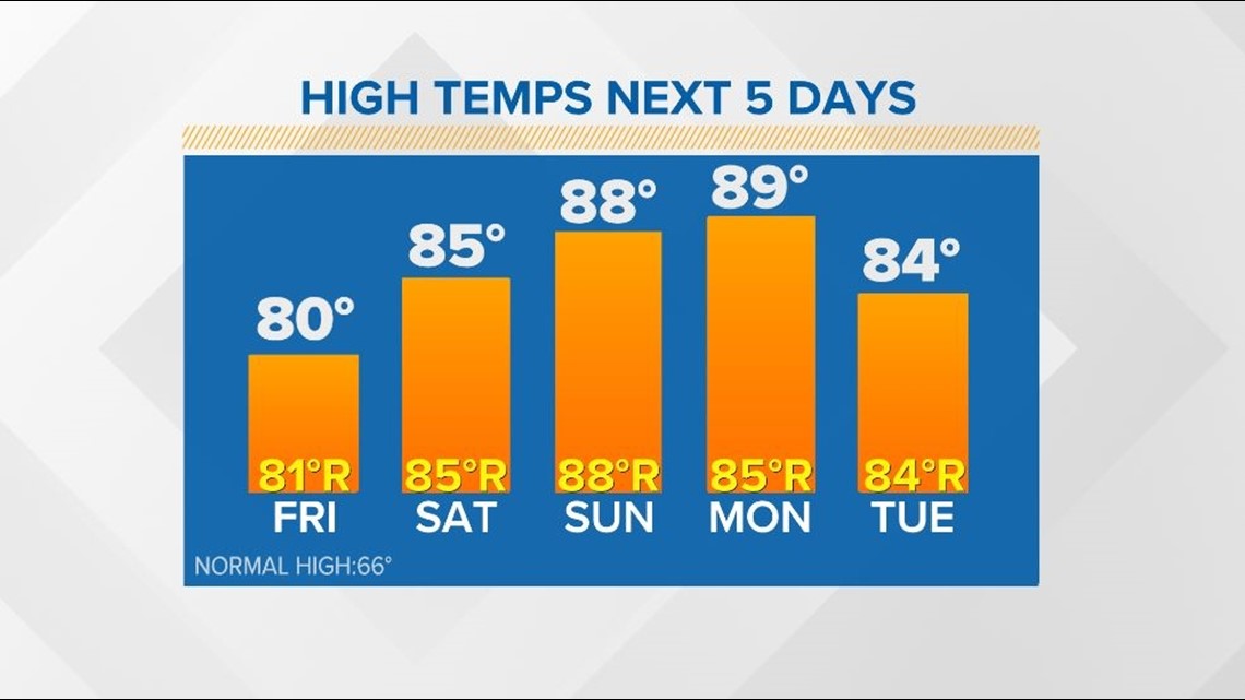
This heat wave will bring the warmest temperatures since October 16 when Seattle hit 88°. It'll also bring the longest stretch of 80° or warmer temperatures. The last time Seattle saw three consecutive days of temperatures 80° or warmer was August 29-31.
This heat wave could string together at least five days in the 80s or warmer for Seattle. The record is four consecutive days of 80 degrees or warmer back in 1963 when Seattle also recorded its warmest May temperature on record of 93.
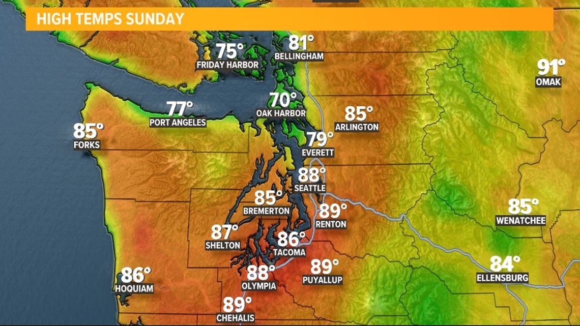
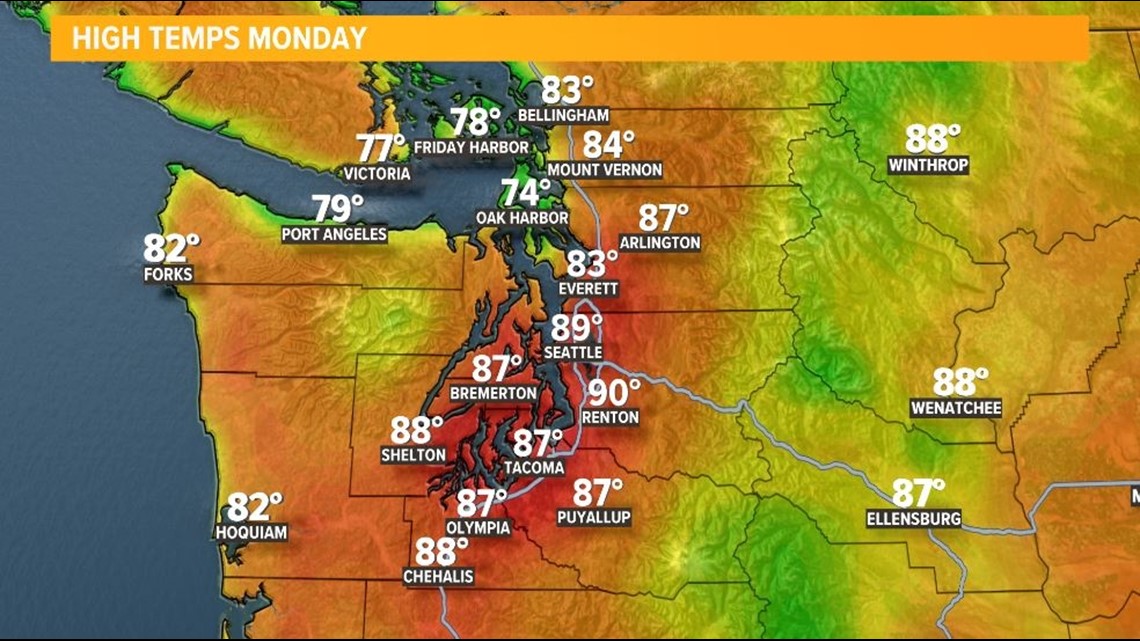
Other areas near Seattle have a shot to see 90s Sunday and Monday. Here's a look at the high-temperature forecast for western Washington on both days.
Sunday high temperature forecast for western Washington

Monday high temperature forecast for western Washington

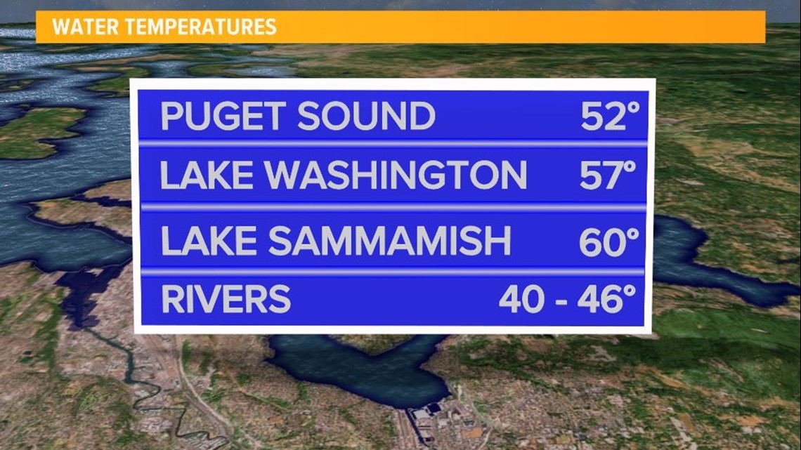
While the hot air temperatures will make many folks want to cool off in area waters, it's important to remember that the water temperatures are still very cold. Local streams and rivers are flowing fast due to rapid snowmelt. If you plan on enjoying the hot weather on the water, please practice all the appropriate safety measures for you, the kids, and the pets.
Current water temperatures

It's also important to remember to never leave your pets and kids in the car and to not walk your pets on paved surfaces when temperatures warm higher than the 70s. Keep checking back for updates and get the proper, safe cooling methods implemented before the heatwave arrives.

