WHATCOM COUNTY, Wash. — Efforts are underway to help those impacted by the latest storm that brought heavy rain, strong winds and flooding to western Washington.
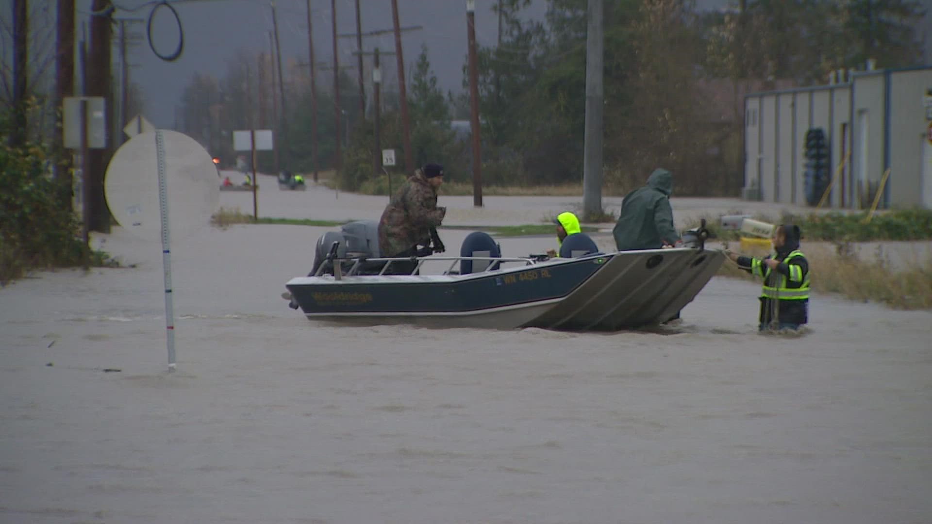
Whatcom County experienced the worst flooding in more than 30 years, and hundreds of residents were displaced. However, floodwaters near Sumas are receding and people are starting to return to their homes.
Below is a live blog of current developments and a list of helpful resources as residents recover from the atmospheric weather event:
Live blog with latest updates:
Thursday
2:30 p.m.: The state is gathering preliminary damage assessments to understand the full scope the impacts and the costs of flood damage to homes and businesses, according to Gov. Jay Inslee. It's unknown if the damage is severe enough to qualify for federal assistance.
Inslee urged those impacted to keep records of the costs they are incurring, damages or assessments of damages to their homes or businesses and provide that information to their local governments. Inslee spoke with FEMA Administrator Deanne Criswell about the damage assessment process and the potential for a presidential disaster declaration.
Inslee said the state is also looking into "creative solutions" to house families whose homes were damaged in the flood. The state expects to have cash assistance available shortly to impacted families and continues to investigate potential short-term shelter and housing options.
1 p.m.: Whatcom County warns that naturally occurring asbestos from Sumas Mountain may be flowing in floodwaters from Swiftwater Creek and the Sumas River.
If you live or work near Everson, Nooksack and Sumas, you could be exposed to asbestos in floodwater, mud or sediment left behind. To protect themselves, the county urges people to use respiratory protection if they're in flooded areas or helping clean up.
12:50 p.m.: Whatcom County is urging those who are able to donate to the Whatcom Community Foundation, which said it is giving 100% of the funds collected to those impacted by floods.
12:30 p.m.: Skagit County says Samish Island Road is dry and Bay View Edison Road is opening soon.
District Line Road at SR 20 and Lafayette Road has also reopened.
Closure signs on SR 20 will move east of District Line to maintain closure the closure where water is still over SR 20.
The shift gives traffic an additional route through Burlington, according to the county.
9:48 a.m.: The city of Sumas is sending volunteers door to door to find out which homes received damage and other details in an effort to gather as much information as possible to apply for federal aid.
The city is also gathering names of Sumas residents who need meals delivered to them.
9:19 a.m.: NWS says that dams along the Skagit were able to absorb a significant amount of the floodwaters, but dam reservoirs are full and must be released. The Flood Warning has been extended through late Friday morning.
Skagit County said that discharge isn't expected to create additional flooding, but those living near dikes may see some seepage in the next few days. This is expected and unrelated to any structural failures.
9:17 a.m.: The Salvation Army Northwest's Emergency Disaster Services team deployed canteens to help those impacted by flooding in Skagit and Whatcom County.
The team is focused on providing food, hygienic items and cleaning supplies.
7:30 a.m.: The mayor of Abbotsford, B.C. said that the east Sumas Prairie continues to fill up with water from the Nooksack River. Crews are working on ways to fix breaches and assess damage to other parts of the area.
4 a.m.: A Flood Warning was extended for the Skagit River at Concrete and continues for the Skagit River in Mount Vernon.
Although the floodwaters are receding, moderate flooding is still expected until Friday near Mount Vernon. The river won't fall below flood stage until late Thursday night.
Wednesday
9:30 p.m.: There are still approximately 100 people being housed in shelters in the Lynden area, according to Whatcom County officials.
As of late Wednesday, water levels continue to recede throughout the county.
The Red Cross opened a shelter at the fairground's Mount Baker Rotary Building at 1775 Front Street, Lynden.
6:30 p.m.: Many Whatcom County roads remain closed. Officials warn that some closed roads may appear to be drivable but may have been compromised during flooding. Whatcom County Public Works will assess roads and bridges in the coming days as waters recede.
4:40 p.m.: Gov. Jay Inslee visited Whatcom County on Wednesday to survey the damage from the flood and meet with local lawmakers. In a briefing, Inslee was told the flood did top all-time flood levels in certain locations and came on faster and stronger than modeling predicted. "That's one of the reasons we had the level of damage that we had," he said.
Inslee said the cities affected by the flood are currently compiling information on the cost of the damages in the hopes of meeting the threshold to qualify for individual federal assistance dollars, but the process would take some time.
In the interim, Inslee said the state was working with the Department of Commerce to see if the state can provide immediate housing assistance and looking into federal housing resources.
Inslee urged homeowners to document the damage to their homes and pass the information on to their local lawmakers to help the state meet the requirements for individualized federal assistance.
2:40 p.m.: Skagit River is the only river with an active Flood Warning, after the warning for the Nooksack at Ferndale ended Wednesday afternoon.
The upper reaches of the Skagit River are expected to drop below flood stage Thursday morning. Water levels should recede below flood stage at Mount Vernon by Thursday night, according to the National Weather Service.
11:52 a.m.: The city of Sumas said it continues to monitor a potential flooding situation in Abbotsford, Canada across the border.
Concerns arose Tuesday that more flooding could occur if the Barrowtown Pump Station near Abbotsford failed, which could happen if more water comes into town from the Nooksack River across the U.S. border.
However, the city of Sumas said the Abbotsford situation is currently "stable," and the city believes they will get 24 hours notice if there is an issue with Abbotsford's pumps.
Meanwhile, the water level has continued to drop in Sumas after the Nooksack River at Everson crested Monday, and the city hopes people can gain access to their homes.
The city says returning power to the remaining areas of town is its priority. The city is also clearing roads not covered in water, setting up a center of operations at city hall and setting out dumpsters for people to put their damaged items.
Residents are advised to contact their insurance companies before throwing anything away since they typically ask for pictures.
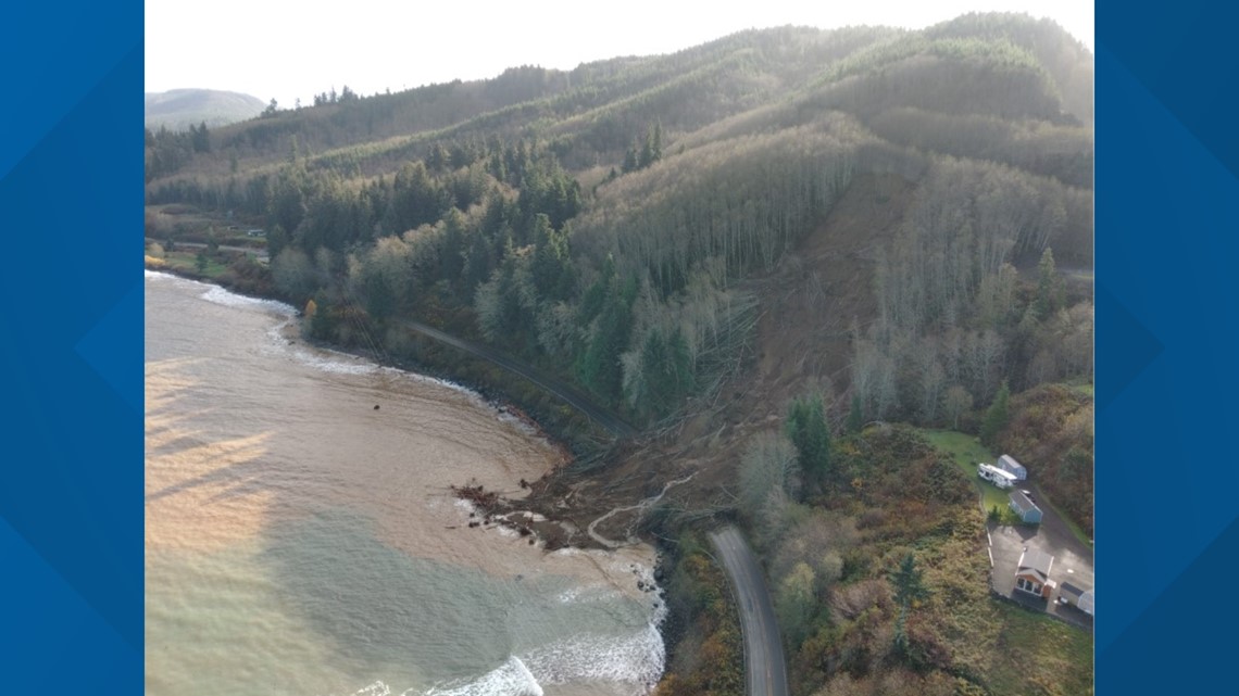
11:37 a.m.: Transportation officials are assessing conditions and clearing debris from several roads on the Olympic Peninsula after landslides. Current road status:
- US 101 south of Forks is fully blocked. A one-lane detour for 4x4 on logging roads is open, according to Clallam County Emergency Management.
- US 101 at Lake Crescent is blocked and still has a lot of debris on the roadway, according to WSDOT.
- US 101 at the Elwha River is open after crews inspected the bridge footings.
- SR 112 has three closures at mileposts 11, 15.8 and 32 due to slides and flooding.


9 a.m.: Gov. Jay Inslee is expected to visit Whatcom County on Wednesday and survey storm damage. Inslee will tour the Whatcom Unified Emergency Coordination Center and meet with first responders, families and officials, according to Inslee's office.
7:30 a.m.: Officials in Abbotsford, Canada gave updates on potential "catastrophic" flooding in the Sumas Prairie north of the Canadian border. Watch in the player below.
Tuesday night, the City of Abbotsford issued a notice for all residents that have not evacuated to do so immediately. Washington state officials are monitoring conditions within the Sumas Prairie as flooding escalates and poses a "significant risk to life."
7 a.m.: Three rivers in western Washington still have Flood Warnings: The Nooksack River at Ferndale, the Skagit River at Mount Vernon and Concrete and the Skokomish River at Potlatch.
The Nooksack will have major flooding until early Thursday morning when it falls below flood stage.
The Skagit is expected to cause major flooding from Sedro-Woolley downstream through Mount Vernon. It will also flood low-lying areas from Rockport to Sedro-Woolley. It is expected to fall below flood stage in Mount Vernon on Thursday afternoon.
The Skokomish is expected to cause minor flooding and fall below flood stage Thursday.
4:55 a.m.: WSDOT has closed State Route 9 south of Francis Road through Clear Lake, Washington due to water over the roadway.
1:15 a.m.: WSDOT says closed State Route 9 at Sumasdue to water over the roadway.
Road Closures
Where to find sandbags
Sandbag options are also available throughout King County. Several locations are open 24/7. Obtaining sand at these sites is free of charge.
Also, anyone needing sandbags in Skagit County should contact the county's department of emergency management at 360-416-1850.
Power Outages
School Closures
Washington State Ferries
Tuesday
11:20 p.m.: Residents of Fir Island and Sterling have been recommended to evacuate. The City of Mount Vernon has canceled voluntary evacuation orders for the West Mount Vernon and the Riverbend / Freeway Drive area.
The National Weather Service extended the flood warning for the Skagit River through late Thursday night, November 18, stating: “The area will dry out with the end of the rainfall for a few days. However, with so much water in the system, it will take some time to drain the floodwaters. In addition, the dams on the Skagit were able to absorb a significant part of the flood but with the reservoirs near maximum pool levels, that water must start being released. This will slow the recession of the river levels downstream.”

